Locating poor air quality in cities
Thanks to a current study with significant participation of the Helmholtz-Zentrum Hereon, the distribution of particulate matter in cities can be calculated more precisely. Within the framework of the United Nations (UN) Sustainable Development Goals (SDGs), the indicator 11.6.2 for capturing exposure to particulate matter in cities can be calculated in greater detail. Until now, the indicator recorded the particulate matter pollution in cities only coarsely. The advantages of the new method are the more precise determination of the indicator and the possibility of uniform application throughout Europe. Using Hamburg as an example, the study shows different levels of pollution according to districts, neighborhoods and even blocks. The study was recently published in the journal Remote Sensing.

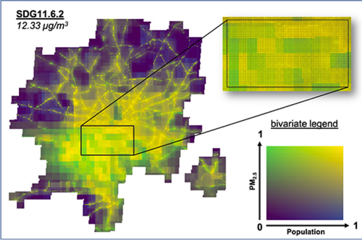
The results of the new modeling approach allow for immediate and easy identification of relevant hotspots of poor air quality. Graphic: Hereon/ Martin Ramacher
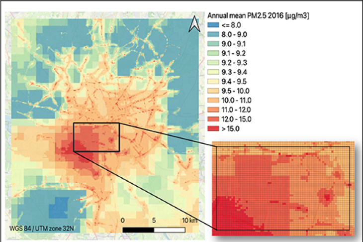
People in big cities breathe bad air. Bad air that consists of particulate matter and other pollutants, which pose health risks to urban citizens. Researchers led by Dr Martin Ramacher of the Hereon Institute of Coastal Environmental Chemistry, in collaboration with the National Observatory of Athens, are now helping to make the determination of particulate matter smaller than 2.5 micrometers (PM2.5) more accurate. To do this, they used openly available EU-wide Copernicus satellite data in combination with the EPISODE-CityChem chemical transport model. The system developed at Hereon was able to model hotspots for bad air at a resolution of 100x100 square meters using Hamburg as an example. The calculated particulate matter concentrations are combined with population data and can thus simultaneously indicate areas with poor air quality and high population density. These areas are of particular interest for achieving air quality improvements. The pioneering aspect of the developed method is the combination of different satellite data, which are freely available for all of Europe, with city-scale model calculations.
Compared with the mean value of 14 micrograms per cubic meter for the entire city previously collected by the World Health Organization (WHO) for the example year 2016 used, Hamburg was actually subject to lower fine particulate matter concentrations of 11 to 12 micrograms per cubic meter as an urban average. However, the new detailed calculations show that pollution levels are distributed differently across the city and can rise to 17 micrograms per cubic meter in some neighborhoods. "In particular, we were able to determine elevated annual mean values for particulate matter concentrations for the sample year 2016 on busy roads and in the industrial area near the port in the south of the Elbe River. While relatively few people live near the industrial areas, we were able to demonstrate that many people live near heavily traveled roads and are affected by elevated concentrations. Such considerations of air pollution hotspots, have so far been unrepresented in the UN indicator. But our approach, in line with the UN indicator, allows to better record pollution levels and can help local decision-makers to initiate countermeasures," says Ramacher. Overall, Hamburg is below the European average for particulate matter pollution compared to other major European cities and does not exceed the annual EU limit of 20 micrograms per cubic meter for particulate matter smaller than 2.5 micrometers (PM2.5).
Background

Graphic: Martin Ramacher
The SDG 11.6.2 indicator was developed by the United Nations to address the threat to public health from urban air pollution globally. The World Health Organization (WHO) published updated guidelines for air quality benchmarks in late September 2021 to respond to the threat of pollution. The effects of those include seven million premature deaths worldwide each year and many millions of people becoming ill. Air pollution is still a major health problem in Europe as well.
The local definition of SDG 11.6.2 indicator brings challenges - mainly because of the diversity of causes of air pollution, for example, from a wide range of emission sources and other influencing factors. The often too few monitoring sites cannot accurately capture the spatial complexity. The study, conducted jointly by Hereon and the National Observatory of Athens, aims to advance the discussion on the potential of the SDG 11.6.2 indicator for local decision-making. This is because detailed inner-city information on pollution and population is needed to fill the research gap that has existed to date and eventually to improve air quality in cities.
Further Information
- Original publication Bailey, J.; Ramacher, M.O.P.; Speyer, O.; Athanasopoulou, E.; Karl, M.; Gerasopoulos, E. Localizing SDG 11.6.2 via Earth Observation, Modelling Applications, and Harmonised City Definitions: Policy Implications on Addressing Air Pollution. Remote Sens. 2023, 15, 1082.
- Website Institute of Coastal Environmental Chemistry
- Website Hereon blog Coastal Science
Contact
Scientist
Phone: +49 (0)4152 87-1561
Institute of Coastal Environmental Chemistry
Helmholtz-Zentrum Hereon
Press Officer
Phone: +49 (0)4152 87-1648
Communication and Media
Helmholtz-Zentrum Hereon
