Research Focus & Projects
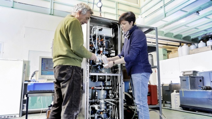
Scientist calibrate a FerryBox in the laboratory.-image: Christian Schmid/Hereon-
Research Focus
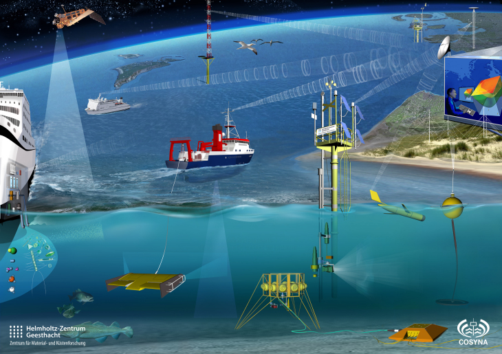
Within the COSYNA framework, measurements are carried out with the help of many different systems such as gliders, buoys, FerryBoxes, satellites or radar. -image: Glynn Gorrick / Hereon-
COSYNA facilitates systematic and continuous observation of the coastal ocean in the North Sea and the Arctic. Computer models, which simulate coastal sea processes, are analysed and improved using the data measured. The objectives are to describe the current environmental condition and make short-term forecasts.
The data made available by COSYNA can assist government bodies, the commercial sector and the public to better plan routine tasks. It can also assist in exceptional situations so that contaminants, oil spills or poisonous algal blooms can be handled properly. An additional area of application lies in long-term estimates and forecasts.
COSYNA also develops and improves scientific products such as North Sea current maps. Furthermore, underwater nodes, FerryBoxes, measurement buoys and other scientific instruments are utilised, developed and optimised
In cooperation with many , COSYNA expands knowledge of the coasts in "our backyard" and globally – as well as on their regional coastal characteristics.
Further information can be found on the COSYNA website.
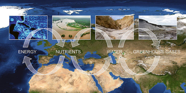
image: Moses website-
The Helmholtz Association is in the process of creating a flexible, mobile measurement system for Earth observation. Nine Helmholtz Association centres will cooperate to set up a measurement system for Earth observation: MOSES – Modular Observation Solutions for Earth Systems. The project will initially be running from 2017 through 2021 and is funded by the Helmholtz Association with a grant of almost €28 million. MOSES is specifically designed to lay the foundation for research into interactions of short-term dynamic events, such as heat waves or extreme rain events, and long-term trends across Earth system compartments. MOSES is being coordinated at the Helmholtz Centre for Environmental Research (UFZ) in Leipzig.
MOSES targets four event chains: heat waves, hydrological extremes, ocean eddies and the thawing of permafrost. The following questions are being adressed: What impact do heatwaves have on water resources, vegetation and air quality? How does flooding of terrestrial ecosystems change coastal regions? How do ocean eddies influence marine energy transport and oceanic food chains? What amount of atmospheric greenhouse gases is released during the thawing of Arctic permafrost soils?
The Institute of Coastal Research coordinates the “Ocean Eddies” event chain and plays a central role in “Hydrological Extremes".
MOSES
Projects
JERICO-S3 will provide a state-of-the-art, fit-for-purpose and visionary observational RI, expertise and high- quality data on European coastal and shelf seas, supporting world-class research, high-impact innovation and a window of European excellence worldwide. It will significantly enhance the current value and relevance of the JERICO-RI, through the implementation of the science and innovation strategy elaborated as part of the JERICO-NEXT project.
The department Global Coast leads the workpackage 2
read more:
JERICO-S3
and
JERICO-RI
JERICO-DS will analyze the needs and propose a design for a state-of-the-art, fit-for-purpose, visionary and sustainable observational European RI providing expertise and high-quality data on European coastal and shelf seas, supporting world-class research, high-impact innovation, and visibility of European excellence worldwide. JERICO-DS will conceptually design the entire picture of the JERICO RI, covering both hardware and software components, and including cutting edge technologies from the sensor level to the information and service distribution to users, hence contributing to the Smart Ocean. JERICO-DS will build on nations’ will and involvement to co-construct the JERICO RI, from the scientific and technical design to the business plan and governance strategy, supporting future engagement during the ESFRI process.
read more:
European Commission - Cordis

CoastPredict contributes to the UN Ocean Decade objective of “A predicted ocean” by improving our understanding of the coastal area processes using a multi-disciplinary and integrated approach and focusing on the many common worldwide features of the coastal ocean that we need to understand for knowledge based and sustainable management. The major science challenge is to advance the understanding of the role played by the coastal ocean in the global ocean dynamics, from short time scale events to climate.
Observing systems and numerical models will be developed to drive a transformative change on how to predict the coastal ocean at global scales, bringing together diverse scientific, technological and socio-economic communities to co-design the system at the global level.
read more:
Website CoastPredict
The department Global Coast works additionally in the projects MOSES and Digital Earth.

